schematic.png
project

Geospatial Lifecycle and Technoeconomic Assessment of Biomass Opportunities

Once biomass residue is identified and its true disposal costs understood, the next question is where and how to redirect it. Pile burning, decomposition, biochar, burial, and bioenergy with carbon capture and storage each perform very differently depending on local feedstock, terrain, transport distance, and site conditions, yet most decisions about which pathway to pursue are still made without a rigorous, site-specific way to compare them. Land managers and project developers need more than a general sense that some alternatives beat pile burning, they need to know which pathway makes sense at a given site, at what cost, and with what carbon and other benefits.

To answer this, we are developing a geospatial life cycle and technoeconomic assessment tool that compares biomass utilization pathways at the site level, integrating carbon efficiency, cost, and feedstock and site characteristics into a single, spatially explicit comparison. This tool, launching soon, allows a user to see which pathway delivers the most durable carbon benefit at the lowest cost for their specific location, rather than relying on landscape-level averages that can obscure enormous site-to-site variation. Looking ahead, we plan to extend the tool to incorporate new and evolving storage and utilization pathways as they mature, as well as additional impact factors beyond carbon, including PM2.5 and other air quality outcomes, so that site-level decisions can account for the full range of benefits and tradeoffs at stake.

Timeline

We are actively seeking funding to support the upcoming, planned extension of our geospatial tools. Please reach out to sinead.crotty@cclab.org for for additional information.

investigation

Identify the pathways, cost drivers, and impact factors relevant to comparing biomass utilization options at the site level

investigation

Compile geospatial data on feedstock availability, terrain, transport distance, and site conditions across priority landscapes

experimentation

Build a geospatial life cycle and technoeconomic assessment tool comparing pile burning, decomposition, biochar, burial, and BECCS across cost and carbon efficiency

implementation

Validate tool outputs against field and literature-derived data

implementation

Extend the tool to include new and evolving storage and utilization pathways as they mature Add additional impact factors beyond carbon, including particulate matter emissions and other air quality outcomes
Currently

We investigate what decision-makers actually need.

Comparing biomass utilization pathways in the abstract is useful and informative, but land managers and project developers need answers for their specific site, approach, an budget. Through conversations with practitioners, project developers, and registries, we found a consistent gap: the science comparing biomass disposal or utilization pathways like pile burning, biochar, burial, and BECCS existed, but nothing translated that science into a tool that could tell someone what pathway made sense for their acreage, at their site conditions, and at what cost.

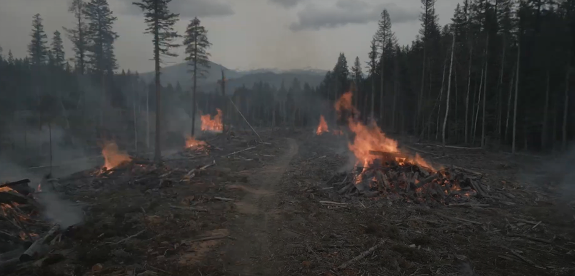
Business-as-usual disposal of biomass residues via pile burning.
Expand

We build geospatial life cycle and technoeconomic assessment tools.

Using this understanding, we developed a tool that layers carbon efficiency and cost data for each biomass utilization pathway onto site-specific geospatial data. This lets a user see, for their location, which pathway delivers the strongest carbon benefit at the lowest cost (or highest revenue), rather than relying on landscape-level averages that can mask enormous site-to-site variation.

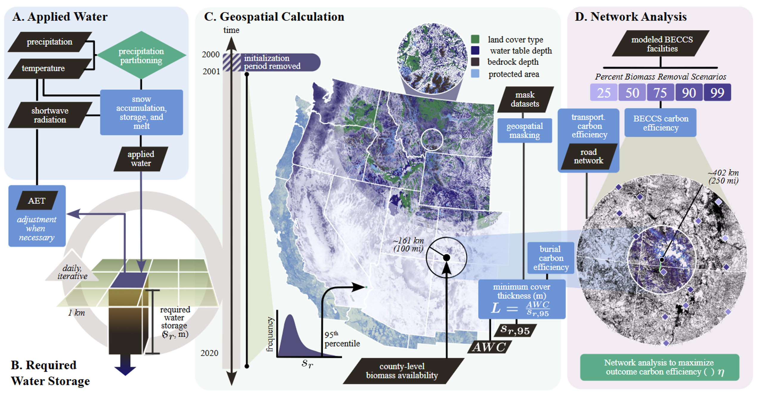
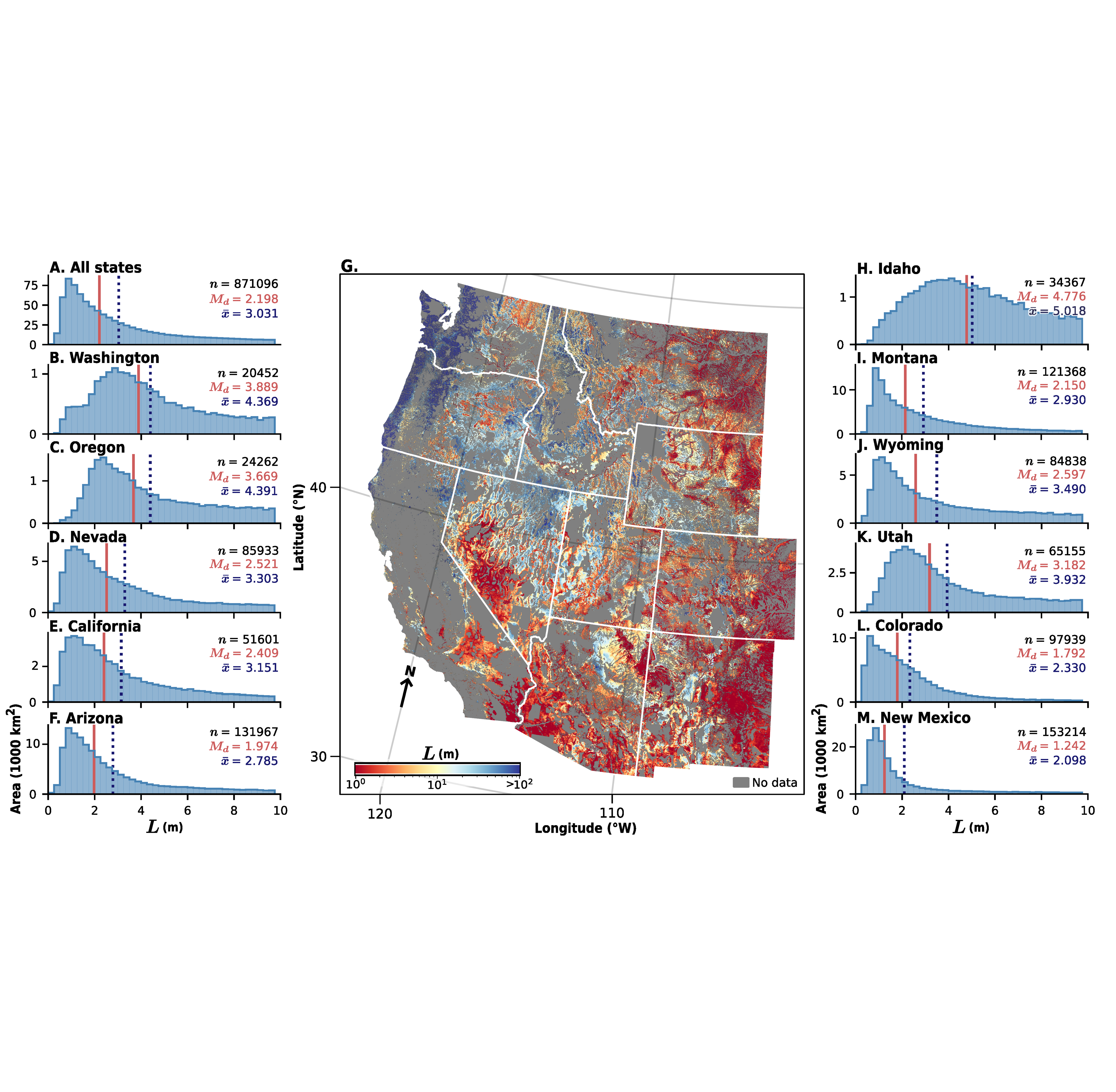
Biomass storage via anoxic burial is a good example of why that site-level detail matters. Beyond excluding oxygen, its success depends on keeping water away from the buried wood, since decomposition needs water to get going, and a cover thick enough to hold onto the wettest years' worth of rain and snowmelt can massively slow the decay process. How thick a cover needs to be depends entirely on local climate and soil, so we built a model that runs the water balance day by day across the western US using 20 years of climate data, producing a cover thickness estimate for any given point. Required burial depth swings from just centimeters to over a kilometer(!) depending on where you are.

Knowing how thick a cover needs to be at a given spot is only half the problem, since the wood still has to get there. So we layered a road network analysis on top, routing each source of residue from fuel reduction treatments to its best available burial site or bioenergy facility within a realistic hauling distance, and calculating the transport cost and emissions along the way. We paired all of this with a full carbon accounting, tracking emissions from harvesting, transport, construction, and long-term decay. We ran the same lifecycle assessment for generalized biochar, bioenergy, and business-as-usual disposal (decay and pile burning), so burial's carbon performance at a given site is always shown against what would, or could, have occurred.

On top of the carbon modeling sits a technoeconomic layer. Pile burning comes out as a straightforward net loss, and agencies are already spending real money to generate that loss--since avoiding catastrophic wildfire is the goal. Alternatives can turn that same spending into a profit instead, though how much depends on assumptions like carbon credit prices and, for some pathways, whether there's a market for the end product. Burial tends to lead in the near term thanks to its low infrastructure needs, though that edge narrows as credit prices rise and higher-infrastructure options become more competitive. Run across the residue expected from wildfire thinning at scale, this points toward a real opportunity: redirecting money already earmarked for disposal into pathways that store carbon and turn a profit instead, rather than asking for new funding to make the switch.

Together, the routing, carbon, and cost models tell a user not just which pathway stores the most carbon, but which one is actually reachable and most economically favorable at their site.

We are expanding the tool to keep pace with a fast-moving field.

Our first version of this tool gave burial the most detailed, mechanistically informed treatment. But a fair comparison across pathways means giving biochar, BECCS, bio-oil injection, and other options that same level of investigation and scrutiny, not just a single average carbon efficiency and cost ranges standing in for what are actually complex, variable processes in their own right. Just as burial's performance depends on cover thickness, soil type, and local water balance, other pathways have their own site-specific drivers, biochar's yield and stability depend on feedstock and pyrolysis conditions, BECCS depends on facility proximity and capture efficiency, and different burial configurations (varying depth, cover design, or engineered barriers) can perform very differently even within the same broad "burial" category. Building out this same depth of modeling for each pathway is our next major phase of work.

A tool like this is only as useful as its ability to keep up with a rapidly evolving landscape of storage and utilization approaches, so this expansion isn't a one-time update. As new pathways emerge and mature, and as our understanding of existing ones deepens, we plan to continue building them into the tool so that users are comparing against the full range of viable options. We also plan to extend the comparison beyond carbon alone, incorporating additional impact factors, like water use efficiency, PM2.5 emissions, and other air quality outcomes, so that site-level decisions can account for the full range of benefits and tradeoffs, including the public health stakes that matter most to the communities near these treatments.

We are actively looking for practitioners who might most benefit from a tool like this. Please reach out to sinead.crotty@cclab.org if you are interested in learning more or contributing to this work.
Expand

Risks & Risk Mitigation

Model Uncertainty and Parameter Sensitivity

Carbon efficiency outcomes for pathways like burial are highly sensitive to specific parameters, feedstock chemistry, methane oxidation rates in soil covers, and how much soil carbon gets disturbed during construction. Small changes in these assumptions can shift a pathway from clearly favorable to only marginally better than the alternatives, or even net negative in a worst case. Because the tool is only as good as the data underlying it, any gaps or uncertainties in the empirical parameters feeding the model risk overstating (or understating) how favorable a given pathway looks at a given site.

Uneven Depth of Investigation Across Pathways

Our first version of this tool models burial with a level of mechanistic detail that other pathways, biochar, BECCS, bio-oil injection, don't yet have. Until every pathway receives that same depth of site-specific modeling, comparisons risk being lopsided, making burial look more rigorously justified simply because it's better characterized, not necessarily because it's the better choice everywhere. Users need to understand that near-term outputs reflect the current state of our modeling, not a final, fully balanced verdict across all pathways.

Economic Sensitivity to Policy and Market Conditions

The technoeconomic layer depends heavily on assumptions like carbon credit prices and the existence of end markets for products like biochar or bioenergy, both of which are volatile and policy-dependent. A pathway that looks profitable under current credit prices or incentive structures could look very different if those policies shift, and land managers making multi-year decisions based on today's numbers may find the economics have moved by the time a project is implemented. This risk is compounded for any near-term policy shifts affecting carbon markets broadly.

Overreliance on Modeled Outputs

A tool that produces a site-specific recommendation can be mistaken for a substitute for on-the-ground verification. Our water balance modeling, for example, only captures how thick a soil cover needs to be to prevent water from reaching buried wood. It doesn't capture the depth needed to fully exclude oxygen, which in many soils requires a meter or more. Gas permeability, how easily oxygen can move through a given cover, depends on soil type, compaction, and construction quality in ways that are highly site- and engineering-specific and simply can't be captured at a landscape scale. Detailed, site-specific hydrologic modeling, the kind used in landfill engineering, would be needed before breaking ground on any actual project, to characterize these dynamics with real, in situ data rather than modeled averages.

Partner with us

We're actively looking to connect with people or organizations who can help sharpen this modeling, especially as we build out the next version and decision-support platforms. 

If you have feedback on how the tool would best support or enable your work, data from your own sites, or expertise in an area we haven't fully built out yet, we'd love to hear from you. 

We're especially interested in connecting with anyone working on PM2.5 or other air quality modeling relevant to biomass disposal and utilization, since that's a priority area for where we want to take this work next. 

Publications